| photos
We spent a fortnight in the Garfagnana region of Tuscany, based near Castelnuovo. For the cyclist who loves climbing quiet wiggly roads, it is perfect. But our stay was marred by bad weather.
The Garfagnana
Pania di Secca |
A lovely shortish ride is the loop through Caréggine. From that village there are wonderful views of the peaks, and of the village Vaglia Sopra. An even more spectacular loop is to cross the Formica pass and descend to Isola Santa – there is a fantastic, rather vertiginous stretch high above the Turrita Secca gorge and its huge limestone cliffs.
A longer ride is to cross towards the coast, via the Cipollaio tunnel or the Vestitio pass. The latter has a tunnel, which was closed for repairs when we were there. There are marble quarries. The Lying Club Italiano map shows several routes from Stazzema to the Grotta de Vento and other places to the east; these do not exist. There are footpaths, but Colin couldn’t even find any trace of these from Stazzema.
The must-do pass
San Romano |
A good roughstuff route is the Foce a Giove – I made a round trip using this route. The ascent was too stony for me to ride much on a road bike, but the southern side is gravelly and ok to ride, and it is very scenic. A possible detour would take you into or by the Horrid of Bottri, a deep gorge.
TCM
Colin, who had his mountain bike, did a couple of roughstuff descents from the unnamed pass above the Foce delle Radici. The pass is indicated by signs marking the Lucca/Modena border. A gravel ridge road, presumably military in origin but now used for forestry, heads southeast. There are several tracks joining it, but if you follow your nose you will come to information signs at the Alpeggio di Monte Albano and then at the Alpeggio delle Lame. The road then descends in earnest, first in broad curves, then along the western slope of a beautiful wooded valley. The surface is poor here. The route rounds a spur and begins to undulate, eventually reaching a junction somewhat below 1000m. Turn left: you soon rejoin tarmac and hurtle past the village of Sillico.
This route
The Apennines |
The alternative descent forks left about 300m before the Alpeggio di Monte Albano. It climbs to the Bassa del Saltello, briefly crossing to the eastern side of the ridge, contours along the western side, and reaches the visiting point of Vetricia. Here it attains the status of a public road and drops steeply to Renaio, after which it is entirely tarmac. It drops further to Braga, a lovely town with good food at l’Osteria.
This route is probably practical in ascent.
CJC
Practicalities
Maps.
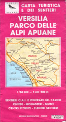 |
There are some good locally produced maps. The best we saw is the one illustrated, again 1:50 000. Though better than the Kompass map, it would be more useful still if it were shifted a little to the north-east. Unlike the preceding maps it has a grid, albeit in lat. and long.
Altitudes. We were not convinced that published altitudes were correct, but didn’t measure with enough care to contradict them.
Accommodation. There seems to be a mini-boom in self-catering accommodation in the area. I suspect that this is due to an error on the part of British tourists, who expect all of Tuscany to be like Chiantishire when in fact the Garfagnana is quite different. We stayed at a wonderful cottage, La Piastra, which has a pool (not much use in the rain), and10 acres of orchards (ditto). It has its own website, but may be easier to book through the Individual Travellers Company [dead link]. It is 3km from Castelnuovo, including about 130m of ascent.
Food. There are decent shops in Castelnuovo and an E. Leclerc in Gallicano which can be seen from the moon. But the restaurants have not really caught up with the mini-boom. The best we found in the area was the Restaurant Bonini rather annoyingly situated at 440m on the pass on the direct road from Castenuovo to Gallicano.
In Pisa we ate a very good meal at Il Connubio.
Access.
Ponte di Maddalena |
Rights of way. Cyclists are not necessarily permitted to use walking trails, but the routes described above are all legal, though the forest tracks have signs banning ‘unauthorised vehicles’, meaning unauthorised motor vehicles.
Transport. Trains run along the Serchio valley, connecting Castelnuovo with Aulla in the north, and with Lucca and then Pisa in the south. To reach La Spezia you need to change trains at Aulla (we didn’t try this). The service as far as Lucca seems reasonable, taking less than an hour. But the trains don’t speed up for the continuation to Pisa, and the extension to Florence seems surprisingly slow (we didn’t try this either). Some of the trains are advertised as carrying bikes (and nor did we we try this).
| photos