Mountainbiking in the Italian Alps, 2012 |
index
We made a little 10-day tour in the Stelvio region and then spent a week relaxing by the pool in a nice house overlooking lake Lugano. We took mountain bikes in touring mode (no suspension, pannier racks and relatively skinny tyres) which made us a little slow on the road climbs but allowed us glorious technical roughstuff. We didn’t do much forward planning apart from outlining the obvious road route taking in the Mortiolo, Gavia and Stelvio passes, and booking hotels. We planned alternating moving-on days with so-called rest days, for which we would make plans on the spot.
Although web information hints that Bormio is a hub of mtb activity we didn’t find it easy to find information on routes in advance. We did find information online about routes near Tirano, and a leaflet is available at the tourist office. A leaflet is also available at Ponte di Legno. The routes descriptions are brief and we generally found the directions a little too brief to follow easily – neither the Tirano ride nor the Ponte di Legno ride was all that much of a success. In Bormio we found more than one leaflet. Again the information is very brief and it wasn’t clear how interesting the routes would be – singletrack versus forest roads. We found a large and glossy brochure of routes in the wider Alta Rezia area packed with compelling, exciting photographs. [Since we did’t see it on our return visit, we’ve scanned in a copy.] From this we found the route over the Bochetta di Forcola. This route is marked as a mtb route on the Kompass map, but it’s helpful to have found information about how practicable it really is.
Routes in the Lugano-Como region are plentiful, varied and just the right technical level to be interesting and rideable. We didn’t find much information locally except for a sort pamphlet for rides near Porlezza. It’s from this that we found the militray road, which we’d never have countenanced from the map. Later, we found out about the series of Luoghi Verticali books from Collana, which include Montain Bike Tra Lecco e Bergamo, Mountain Bike in Lombardia e Canton Ticino.
Tirano and Ponte di Legno
We flew Birmingham to Malpensa with an airline whose name we forgot, and got a bus to Milan. This is easy. Milan deserves more attention than the hour’s evening ramble we gave it. We took the train to Tirano in the morning. That’s easy too. The bikes were still bagged and we took a taxi. Milan taxi drivers, on the basis of two samples, are friendly and helpful. Tirano is the bottom end of the Bernina Express railway and the station end of town is full of trainloads of Swiss. The old part of town is quiet and crammed with gorgeous old palazzi. We attempted a ride but we’d set off too late. The tourist office’s leaflet had a very sexy photo of a roughstuff hairpin bend but we never even made it to top of the climb. It wasn’t terribly well signposted despite being in Switzerland.
Tirano to Ponte di Lengo took in the Mortirolo but not via the classic route, instead climbing to the ridge direct from Tirano. So I don’t know if we cheated by not taking in the really steep bits and it probably would have counted as cheating on steep bits by having a 22T chainring anyway. The opposite of cheating was shown to us on our descent by a hand-cyclist coming up the steep bends. That was impressive.
Ponte di Legno’s a funny sort of place. It must be something of a ski resort in winter; in summer it’s full of families and it has the slight air of a seaside town in that there are a lot of people around on holiday but there is not actually all that much for them to do but stroll around town and eat ice-cream. There appears to be a fair selection of waymarked mountain bike routes, enthusiastically described in a well-produced leaflet but the reality is that they are very poorly waymarked and not all that wonderful as routes either. But we only tried the one.
The Gavia
In town we’d seen a postcard of the Gavia old road, all roughstuff and no guard rails, and wow, of course we so much wanted to do it, so we asked around but nobody had heard of it and if there really was an alternative old route the map was keeping well secret by not allowing for any other route in the geographical constraints bar the existing road. We were somewhat baffled. Turns out all it amounts to is the section of road outside of the tunnel, but it makes a good photo, especially good for scaring parents. The Gavia’s a great little road and I think we forgot it’s nearly as high as the Stelvio – in the grand reckoning of Alpine passes it’s one of the big boys. Its narrowness and lesser celebrity mean it’s quiet enough, the summit still looks like a mountain summit and yet has a decent restaurant which serves pasta with potato sauce and, somewhat unnervingly, grappa to motorists. You can buy postcards of the Giro when it snowed and also of when the Pope rode up here. We descended the steep and more spectacular side with a little regret that we hadn’t gone up the hard way but it did start to rain from an enormous black valley-sized cloud so we cared more about that than inappropriate guilt. We retrieved a small amount of kudos by taking the roughstuff alternative to the valley road, a forest track with some up mixed in with the general downward trend.
The Torre dei Fraile
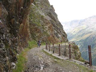
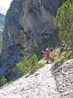
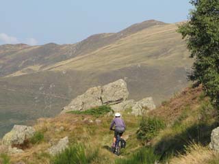
Just north of Bormio there’s a spectacular road to the Torre dei Fraile. It’s a stunning series of zigzags up beside a cliff, which is finally traversed by a tunnel. It’s only fairly recently been surfaced and therefore was irritatingly full of roadies going faster than us, and much worse, some guys on road skis. They were fit, though. We knew we would win in the end, because we had a plan, and we were defining the rules of the contest. Our choice of descent was an enterprising one which no roadie nor road-ski would go near. I call it a plan, but it was more accurately described as a misunderstanding. Or a mistake. I’d thought I had seen the route marked as a cycle route. We checked it with a guy at the hotel, who said we wouldn’t be to ride it all, which was indeed true, but we accept a bit of walking now and again as the usual price of fun. It started just great with a narrow flowing path through forest and into clearings. It became a little edgy, with a steep and long drop to the right; we abandoned riding because of the risks. The path approached an area of cliff, and hastily descended. It was loose and steep and may have been quite all right for just walking, but it didn’t feel at all safe negotiating a bike along. Moreover very time we’d managed a sketchy section and felt that must have been the worst, we’d see another section ahead that looked like the path had slid away. I think we’re inordinately freaked by the possibility of landslide-damaged routes after the Kumaon escapade. When we’d finally cleared the cliff section we could both admit how shaky we’d felt. There followed some steep zigzags, then less steep and Colin could ride some of these. Towards the end the path does get better, and once we were on a clearer section facing towards Bormio, we had some good rideable sections.
Stelvio
Part of our reason for doing this trip is that I was convinced Colin wanted to ride over the Stelvio. He says that he may have expressed slight interest some years ago. We had intended to ride over the Umbrail pass, round the valleys and up to Stelvio village, but as we approched the climb we couldn’t resist riding all the way up and down to the village. A factor was the weather forecast – the day we rode over it was brilliantly sunny but was forecast bad for the return.
Stelvio village
. We rode up from Stilfs village to the refuge Obere Stilfser Alm, getting lost in the process. Several times. It is a long climb anyway. From the hut, the path on the Kompass map, labelled as no.11 is marked a possible MTB route. It’s a narrow singletrack skirting the upper edge of the forest and is utterly delightfully flowing, and studded with intersting and challenging tree-roots and other obstacles (not all of which we could do). The map shows the route descending in a wiggly way through the woods but the obvious route cyclists have taken stays high (no 4 on the map) and winds up on the forest road. From here it was forest roads most of the way back, following signs to Stelvio, but the last bit on a loose stony track into the village with a sharp right-hand bend which, as usual, Colin could do but I couldn’t. Stilfs village is very Sud-Tirol, they all speak German, it’s very pretty. We had pasta for lunch and about 500g came presented in a large pan – each. There is an alarming road-sign indicating a 40% gradient road. The road is nothing of the sort but the sign’s good to pose by.
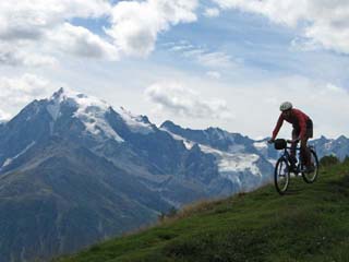
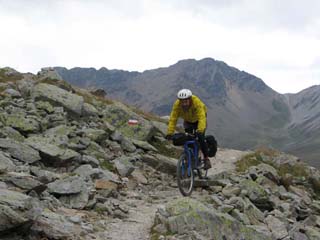
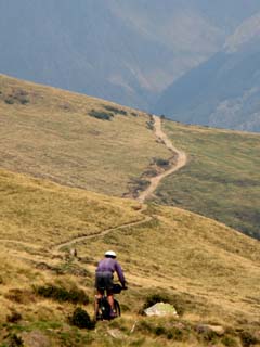
Bochetta di Forcola. This we found listed as part of a longer route suggestion on the Alta Rezia booklet. We’d ridden the western side of the Stelvio on a day forecast to rain. We lunched at the cafe at the top of the Umbrail pass (in Switzerland) and wacthed a long string of mtb-ers set off. The path looks magnificent route from the pass – staying high and corniching the ridge, crseting the next ridge, with spacious views all around. It’s eminently rideable, mostly – with a good scattering of technical obstacles. The last section is steep and a push. Unfortunately for us, by the time we got to the top it was raining and the descent wasn’t the hoped-for delight. It’s a wider path this side, really more of a track, and at times it’s loose and rocky. We dropped to a building. I think there were sheep around but I’d been more focused on staying upright. There was a bedraggled sheepdog. The presence of dog by a building warmth and homeliness. But the building was shut up and the dog alone.
The track continued down. The clouds were low and the rain was rain and it looked awfully exactly like Snowdonia but very much bigger. Lower down the track patchily resembled a gravel road and sometimes more like a pile of washed-up rubble. We saw the big mtb party descending from the left. They’d clearly come a longer route, one certainly more ambitious. We left them to plunge the rest of the road, steep, gravelly, swinging down on one side of the forested valley, to the other. They vanished from sight within a minute, riding at about 10 times our speed.
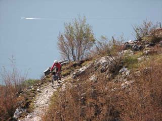
Lake Lugano and Lake Como
We rented a sweet little house just above Porlezza, on a road that’s still giving us nightmares; our pennance for the sin of hiring a car. It would have been fine on a bike The car was an extravagance. We made as much use of it as we could bother, though driving in this region is only a pleasure if you’re insane.
We didn’t have great weather the first few days. We investigated a few short routes which were excellent in parts but suffered from the usual absence of signposting and wild inaccuracies in mapping. But once we’d found our way around we sounded out three superb rides.
Lugano Val Colla ridge.
There’s a walking route all along the ridge around the Val Colla, from Lugano, and a leaflet in the house described it all. It was clearly a fantastic route, the Kompass maps alleged its cycleability and not a small part of its appeal was it being in Switzerland giving us an associated greater confidence in the signposting.
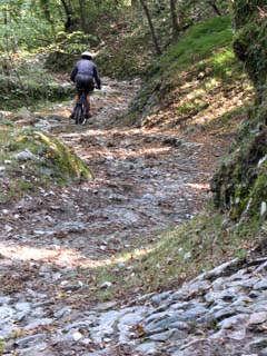
Ten km up the road gets you to Buggiolo. We used the car for this and we don’t care. We’d done the road climb a few days ago. From here a white-road takes you to the ridge that forms the border with Switzerland. The white road was barred to motor vehicles and announced its intentions immediately by presenting us with a 1:6 wall of concrete. When the gradient relented the concrete decided we didn’t need its help and turned the road over to rocks and suchlike. Halfway up there’s a sturdy warm stone chapel with a grand overlook of the valley. This took ages. I asked Colin how far we’d come and he said 1.6km which didn’t sound very far. We’d climbed 200m, which did. The track contined slightly less severely, to the ridge and the border, where there’s a refuge nearby.
The route is very well signposted and it’s pretty clear path of good width. The first section is superb. There are grand views all over the valley and the path has some technical interest, and shoots in and out of little side valleys. It stays high and there’s not too much up and down. The second section after the Pietrarossa refuge is more straightforward and flowing. From Torrettone the corniche path continues along, but for our route we descended through the woods to Signora. This was fantastic, a huge long descent, again not too technical but great fun with some steps and tight bends.
Once at the road, finding lunch was the obstacle. There are villages but it wasn’t clear which would contain lunch and although as the crow flies they aren’t all that far apart, we aren’t crows. We recklessly descended steeply to Maglio di Colla – which could well have been a costly mistake – but it did have a decent enough place serving gnocchi and would take Euros.
A long climb follows, but mostly on road or good track, through Cimadera towards the Pairolo refuge but turning left towards the Bochetta S Bernardo. A lovely section in the woods, a wide track in open ground with the odd technical detail. Then a climb to the pass. We saw a handful of other riders here. The last descent to Paso S Lucio is exhilarating, fast singletrack.
Bochetta di Nava military road. This route was described in a leaflet from the Porlezza Tourist office. We’d have never contemplated it from the map – it looks completely insane. From Cardano you take the Golf–course road and somehow go across the golf course to pick up a steep lane towards the Bochetta di Nava. The lane is phenomenally steep, mostly concrete alternating with gravel. Once over the top of the pass there are a few cottages where you have to get onto the left side of the valley – it’s not all that clear but the old road is pretty obvious once you find it. It descends spectacularly with some tight bends; it’s not as exposed as you might fear as the track’s pretty wide. The views over the lake and back to the cliffs you’re descending, are stunning. It’s fairly rocky at times but we managed most of it.
Menaggio has plenty of gelaterie. We rode back through Pianure and Codogna, which was ok but it’s a bit difficult to find the route. The last climb up from the river was a push.
Ridge above Bellagio. This is the last section of the long high route Como to Bellagio Dorsale del Triangulo Lariano. We got the ferry to Bellagio and rode up the road to Parco Monte San Primo. From here you take a small road towards Rifugio Martina, but signposting’s a bit patchy. You follow the track, through a gate marked no-entry, then there’s a nice singletrack with roots in woods. After that it’s mostly a gravel road until nearer the end, when the old mule road gets itself back into roots and stone steps. This was all great fun, even though there hadn’t been that much of it. We had lunch at Silvio’s.
index
|