| previous visit | photos : route notes
Col du Kerdous |
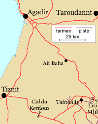
We spent the first week of March 2004 cycling to, around, and back from Tafraoute at the western end of the Moroccan Anti-Atlas. We had been there before, trekking with Exodus in late 1992.
This
 |
General
The Moroccan tourist industry has suffered a lot since the terrorist attacks on New York in 2001, with American visitors in particular staying away. We had heard of stone-throwing by children, but encountered nothing but friendliness and occasional requests for stylos and bonbons.
Southern Morocco has been smitten by a plague of camper vans which drive in huge convoys from campsite to campsite.
The bank stalls at Agadir airport exchange only cash. Credit cards and travellers’ cheques can be used in many places, but the electronic equipment used for exchange transactions seems unreliable.
We stayed in upmarket hotels, booked from England by telephone and confirmed by fax.
Route-finding
 |
The route notes which follow are on four pages:
Aït Baha–Tafraoute : gorges : Tizi Mlil old road : Tafraoute–Tiznit.
Guide books
We consulted up-to-date versions of the Rough Guide, the Lonely Planet, and the Footprint, and a slightly dated one of the Cadogan guide. The Rough Guide was the best, but all were unsatisfactory from a cycling point of view.
Maps
The red Michelin map is serviceable but has all the defects of a small-scale motoring map and is not without errors.
The main survey of Morocco seems to have been conducted by the Ministry for Agrarian Reform in the early 70s, resulting in a 1:100 000 mapping. Copies of a few sheets can sometimes be found; we have maps from this series for the Toubkal region. When we visited Morocco in 1992 we were given a photocopy of part of the Tafraoute map.
However the Soviet 1:200 000 maps are more readily available. Several specialist retailers have them on their catalogues, though they are shockingly expensive and often don’t exist when you ask for them. Omnimap provide soft copy versions, which at least won’t run out. Be warned though that they weigh in at 18 Mbytes and take more than an hour to download over a telephone connection.
The maps seem to be copied from the older Agrarian Reform series with a Soviet grid imposed and a Cyrillic rendering of place names. Pistes are classified as gravel tracks/forest tracks/pack animal tracks, but I doubt that any faith should be placed in these designations.
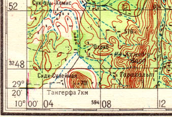 |
A kilometre grid is inscribed around the border. To convert to a metre grid add 3 extra digits. The 701m spot height is thus given the reference
59406500 3246900.
To convert to UTM, subtract 59 million from the easting and 1400 from the northing. The same spot height is therefore given the UTM reference
|
29 R 0406500 |
(I assume that the 59 million is exact and comes from a different numbering convention, while the 1400 is approximate and owes to a different estimate of the ellipticality of the globe.)
On this site grid references are in UTM. The zone is 29R.
The page border comes from an old door seen in the Hôtel de Kerdous.
| previous visit | photos : route notes