| photos : general info : route notes : narrative
In September and October 2003 we made a visit to the north of India which we had been planning for some time. These pages contain some notes and photographs of our visit and a map drawn up from it.
We spent the first few days in the green Shimla hills, descending to the Sutlej valley (765m) in order to cross the Jalori pass (3050m) over 2 days, encountering the first of 2 landslide areas in the process.
We then dropped down into the Kullu valley and rode to Manali at its head. From here a 2000m climb (in one day) took us over the 3820m Rohtang Jot into the barren region of Lahaul which we had visited before.
 |
click for more detail |
After following the Chandra valley for a day we crossed our third and final pass: the Kunzum La (4335m), not a long climb because we were already quite high.
We were now in Spiti, another barren Tibetan region. We followed the Spiti river south through attractive scenery, meeting a second landslip area north of Nako. Although we were following a river downstream we took sidetrips up valleys and hillsides. These often brought our days to strenuous conclusions.
Where the Spiti river joins the Sutlej we entered the region of Kinnaur. The scenery becomes progressively greener: first Tibetan, then Alpine, and finally lush and tropical with orange and banana trees.
A short taxi ride took us back to our starting point.
We rode mountain bikes and carried a tent and camping equipment. Only about 2 days’ riding were on unsurfaced roads, but they were bumpy and a mountain bike is almost essential. We camped for 5 nights, usually from choice. The route verges on being practical for a lightly laden touring bike. The roads are being improved and guesthouses occasionally built, so in future years it may be easier.

The route notes are spread over five pages, each with thumbnail links to photos. There are 50 photos in total. The best way to visit them is from the route notes, but alternatively you can go to the first and follow the links through them.
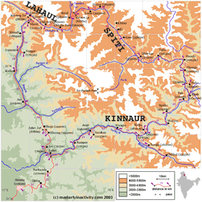
The sketch map above is reduced from the much clearer high-resolution version, which may take a while to download. The information shown was collected during our tour, and is considerably more accurate than any of the published maps.
| Shimla–Manali | Manali–Hanse | Hanse–Nako | Nako–Kalpa | Kalpa–Rampur | ||||
| Route map | Ride stats | |||||||
2004 Update. 2004 was a difficult year in Kinnaur. Careless blasting by Chinese road engineers in Tibet caused a landslide which blocked the Parchu Nallah, a tributary of the Sutlej, creating a new lake. Fear of flooding if the water broke through the dam led to Kinnaur being closed to tourists for several weeks in August/September. The apple farmers were hit during their harvest season by the difficulty of insuring lorries to carry their crops.
The Indian authorities announced a plan to reroute the road above Kalpa higher up the valley, following the old Hindustan-Tibet highway, and so presumably linking the villages currently far from the road.
Aug. 2005 Update. This year has been even worse. Heavy rains and the partial breaching of the Parchu Dam led to floods along the Sutlej, sweeping away several bridges.
Plans to route the road higher up the valley sides were restated. No one seems to have any idea what to do at Mailing.
A road has been started to cross the Saach pass linking Chamba with Killar. The BRO made an ambitious proposal to complete an all-weather road to Leh by tunnelling first the Rohtang, then the Shingo La, with a newly blasted route along the Zanskar valley as finale.
At least one more tourist was reported to have gone missing in the Parbati valley. Please avoid this area, and don’t assume that the Kullu valley is safe.
May 2006 Update. The last bridge over the Sutlej was repaired in November.
June 2007 Update. An ‘amazing’ new road has been built running directly from Chango to Nako, described by David James as a ‘bloody hard climb’. But I hear that the engineers are having difficulties with their projected route along the Zanskar valley.
Notes on the map. The relief is taken from the military maps. The course of roads is taken from the same source, but corrected once or twice from observation. Place names mostly follow the Nest & Wings map. Distances are taken from kilometrestones with a couple of small corrections; they are thought to be reliable. Altitudes were measured on a Sumto wrist altimeter. Eight of them were also measured on a GPS unit and the altimeter readings were retrospectively calibrated by subtracting the average difference (which was 35m). It is these corrected figures that we use. (Added 2005: I place less faith in GPS than I did in 2003. I suspect that the heights will be more correct if you add back the 35m I subtracted.)
| photos : general info : route notes : narrative