We made a family visit to Australia in Oct/Nov 2004, taking mountain bikes with us. Our arrival put an end to several years’ drought. We spent most of our time in the Canberra region where much of the landscape bore the scars of the forest fires of Jan 2003. Nonetheless Canberra makes admirable provision for cyclists, and the surrounding countryside is properly mountainous. But don’t expect the jagged peaks of the great ranges: most Australian mountains are really well worn plateaux.
The
 |
Picnic on the |
In
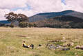
Mt. Clear | ||
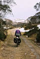
The Mt. Clear ride, like much off-road cycling in Australia, follows fire trails: vehicle-width tracks made and maintained for fire-fighting vehicles. Cyclists are permitted to use them in national parks; elsewhere I suppose they are private land and need explicit permission. The advice is given not to rely on maps for them because some fall into disuse and quickly become overgrown.
Kosciuszko Circuit
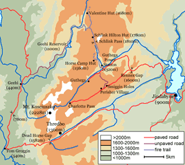 |
click to enlarge |
Our main ride was a circuit of Mt. Kosciuszko based on a route in the Lonely Planet, which entails camping. We did it in rather a hurry to squeeze it in between two periods of rain. It would have been nice to have had time to potter around Charlotte Pass and other nearby places.
Weds morning. Bus to Jindabyne, where we assembled the bikes and ate our sandwiches in the visitor centre car park.
Weds afternoon (42km, 1260m ascent). From Jindabyne it’s a long, well graded tarmac ascent to Rennex Gap, and then an undulating descent to Guthega Power Station. Here we crossed the river and joined a gravel track which climbed steep zigzags up the side of the valley. (A misleading sign on the gate said ‘walkers only’.) The route now rises gently along a ridge northwards on a good fire trail.
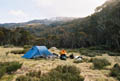 |
Camping at |
 |
Mt. Kosciuszko |
Thurs
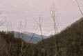
 |
Nearing |
Fri morning (25km, 1100m). We cooked our porridge in the porch of the campsite lavatory, rolled up our sodden tent, and began the climb to Dead Horse Gap. Soon we were cold wet and miserable. This stretch of road is supposed to be scenic, but we could see nothing but cloud, rain and gloom. We gained height slowly (taking 2hrs 20' to the pass), and could hardly go faster on the brief descent to Thredbo because our hands were so cold. We had no hesitation in checking into the best hotel, the Alpine, where Colin’s hands were too numb to fill in the registration form (he had to dictate). We enjoyed exclusive use of the hotel’s vast drying room.
A hot bath and lunch restored morale. We spent the afternoon watching the rain pelting a tin roof outside, often with remarkable ferocity, occasionally turning to hail or snow. The next morning, rain still falling, we arranged the bus trip back to Canberra.
Practicalities
We got most info on the Kosciuszko route from the Lonely Planet guide ‘Cycling Australia’.
Canberra has an enviably effective cycling club Pedal Power, whose book ‘Cycle Canberra’ describes many rides, both on and off road. The Mt. Clear circuit was taken from it. It may be that stocks of the current edition are running low (we saw none for sale), but most of the information is available from the club’s web site, albeit in a less attractive form. This web site is a treasure trove.
Pedal Power | Cycle Canberra | rides library | Mt. Clear ride
We used a variety of maps for the Kosciuszko ride. Most of the route is on the Auslig/Natmap 1:250 000 sheet SJ55-03 (Tallangata), though Jindabyne falls to the east. This map is in any case too small scale to help in following fire trails. The Natmap 1:100 000 sheet 8525 (Kosciusko [sic]) is probably the best to use, though it omits the southern part around Dead Horse Gap and Thredbo. (Since this is on tarmac, the Lonely Planet map is sufficient.) We obtained these maps by mail order from Guides Galore, who unfortunately took ages to dispatch them. The largest scale map we used (bought in Canberra) was LPI sheet 8525-2N (Geehi Dam), but this omits both Jindabyne and the southern part of the route.
The Bullocks Flat ski tube no longer runs except in winter.
The year-round Alpinexpress bus service between Canberra and Thredbo via Jindabyne is operated by Transborder. We found it friendly and efficient. Cyclists are asked to box their bikes. When we got to Jindabyne the driver took the boxes back to Canberra, and for the return journey we telephoned and arranged for the boxes to travel up to Thredbo. Since the office is unmanned during weekends this took a lot of telephoning, and the boxes create a lot of inconvenience for everyone. A cyclist who turned up at Jindabyne with an unboxed bike was allowed to travel.
CJC. 2004