In 1996 UNESCO held a beauty contest of world mountains – presumably there are judges who are experts in these matters – and Alpamayo, in the Cordillera Blanca in Peru, was declared the loveliest of all. Alpamayo itself is hidden away in a less accessible corner in the north of the range, but there are plenty of other wonderful summits: Huandoy, Huascarán, Chopicallqui – names that are unfamiliar to most Europeans.
To see the beauty of the mountains properly, you really have to climb them – or at least trek high. Those of us with no patience for walking are usually limited to where the roads can go. What is extraordinary about the Cordillera Blanca are the two rough roads that cross through the heart of the range, passing either side Huascarán, Peru’s highest peak. That ride over the mountains and back again, over the 4500m passes of Llanganuco and Olímpica, is surely the most spectacular cycle route on the entire planet. Needless to say, spectacular does not equate with easy.
These mountains are in the northern half of Peru. Between the Cordillera Blanca and the sea is a lower range, the Cordillera Negra. Separating the two ranges is a high valley – the Callejón de Huaylas. To the south, the mountains and valley merge into high rolling moorlands called puno. The Rio Santa rises here, in a boggy lake and flows through the valley. Then, to the north, it cuts a steep gorge through barren rock, and passes through deserts to the coast.
We more or less followed the river in from the coast. In this season the coast is under an almost permanent cloud, while the mountains are clear. It was not the most inspiring start, as desert only really works in sunshine. The grimness was relieved for a while when we met the Rio Santa valley, where there are patches of fertile ground, but before long they peter out; beyond there, it is stark riding. Where side streams meet the main valley there are isolated hamlets in greenery, but otherwise it’s nothing but pure rock and the forlorn remains of derelict mines. At least we were in the sunshine now, though it was hard riding for us, for it was hot in that sunshine, and the road surface atrocious.
The valley walls gradually close in, and the river enters an almost sheer-walled canyon. The road is cut into the rock, and works in and out of tunnels, which, not being lit, made an interesting challenge. The canyon has a forbidding air: in the days of the Sendero Luminoso terrorists, this wasn’t a very safe area, and though it’s fine now, when you know its past history, you can imagine and feel the isolation, and the threat, of the turns and twists of the concealing rock walls.
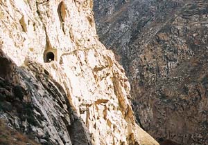 |
Cañon del Pato |
You emerge from the final tunnel onto tarmac as soothing as cold beer. After two and a half days on roughstuff, it was a very odd sensation to be riding on tarmac. It almost felt like it was too good, that we ought not to be riding on such a smooth surface – as if it were the marble floor of the lobby of a 5-star hotel. And the scenery was a transformation too – after days in the deserts, this green and fertile land was a real Shangri-La. High above us were our first real sights of the summits of snow peaks; we took 1000 photographs of the first one we saw – just in case it were to start raining within the half hour and continue for the next 3 weeks. Further up the road was Caraz, a delightful colonial town with a friendly and relaxed atmosphere, and deservedly famous for its ice cream. We stayed a week.
It wasn't solely for the ice cream. Before we were to cross the high passes, it made sense to acclimatise properly, and besides, there were good rides to be done here. There are a handful of dead-end roads that give access to high valleys. One such goes up to Laguna Parón, a beautiful lake surrounded by snow peaks. At first the road winds up through the lower slopes of the mountains, through villages, and fields, and fragrant eucalyptus woods. The local people grow all sorts of crops: wheat, peas, tomatoes, artichokes, and carnations. It’s pleasant to ride through the villages, as long as you have no objection to being called gringo. The people are a friendly bunch. They like to listen to music in the fields. On this ride, we heard a live band playing in one village: jolly Inca stuff, even jazzy sounding – and probably improvised to some extent. The women wear bright colours, skirts with many petticoats, and broad-brimmed hats.
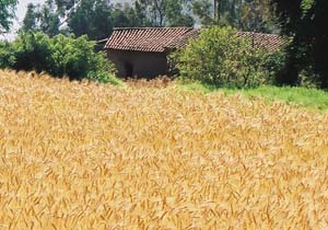 |
Wheat |
At about 3000m the valley walls are steeper, and there is no more settlement. The road enters a high canyon. These high valleys had been formed by glaciers in the Ice Age, and are the classic U-shape, walled with looming cliffs of polished dark rock. Progress was slow: at 4000m the air pressure is only 60% what it is at sea level, and the roads are made of treacle.
We camped in the grounds of the refuge at the end of the road, under one of the icy sides of Huandoy. The lake is a suspiciously unreal turquoise, as if someone has been fiddling with the colour balance. Actually, all the lakes in the mountains are like this, taking on their unbelievable colours from glacial silts. In the morning, we walked towards the end of the lake, which crowned by the exquisitely triangular Nevado Pirámide, and the fluted ridge leading to rocky Chacraraju. All around the lakeside are lupin shrubs, flowers of deep indigo and bright yellow.
Huandoy from Laguna Parón, at dawn |
Our other big excursion from Caraz was what we were calling the Killer Ride even well before we ’d turned a pedal along it. It stands out on the map, a loop of manically wiggling road, climbing to over 4000m over the Cordillera Negra. It was rather obvious it was going to be a long day. We had to make an early start, and were riding along the valley when the sun had only just reached the summits. The road up through Huata is in good condition; we climbed innumerable easy hairpin bends (actually, there were 67; we made sure we counted every single one of the damned things) through farmed land dotted with pleasant houses, for hours, until the crest began to stop looking impossibly far, but still, it was above us, and all we could see was more mountainside, an infinity of golden grass, and a scattering of tiny road signs above us marking yet more bends.
Over to the other side of the Callejon were splendid panoramic views of the Cordillera Blanca. As we climbed, we saw greater vistas, though clouds were creeping over by midmorning. The top, when it eventually came, was a little understated. No amount of hard staring at a drystone wall and a barbed wire fence will turn it into an Auberge serving café au lait and tarte aux myrtilles. This was a feature of the passes that we would have to get used to.
The top of the Cordillera Negra is a vast rolling upland of utter emptiness. We came to a junction – to the right, the road descends to the coast, to the left, after a short and heartily resented climb, it descends quite spectacularly into something like a deep pit where we can see villages sited in impossibly inaccessible places, and fields opposite on what seems like a vertical slope. The road suface is more quarry than road, and I did not like it much.
And now we were ready for the big trip. We spent a day preparing, by completing our definitive survey of Caraz’s extensive range of ice cream. It was outside the heladeria that we met Gregg, who was on his way to Patagonia, along with a whole bunch of other cyclists who’d met up. Cyclists doing the Alaska-Patagonia grand tour eventually all run into each other, because they all have to be on more or less the same schedule with the seasons. With Gregg were Harald from Germany, Wauter from Belgium and Jeannette and Gerrit from the Netherlands. We told them our plans and they were rather taken with doing the same route. It makes an interesting deviation from the more direct route to Huaraz, which would have taken all of a long morning.
The first stage was to climb to the high Llanganuco valley, a glacial trench at about 4000m. It is flanked by the mountains of Huandoy to the north, and Huascarán to the south. Huascarán is the bigger, a huge shimmering dome of snow and ice. It is an extraordinary sight from the lower slopes, which are warm and sunny, tropical; above these, Huascarán looks like an alien planet that has landed on the earth. Huandoy has two peaks, like carved horns, more shapely than Huascarán. You lose the views in the Llanganuco valley, but here there are a pair of lakes. We camped at the far end, at the foot of the remaining climb to the pass. We could see the pass summit, a conspicuous notch in the ridge, and make out the tracks of the many zigzags. Later, first Harald, then Gregg and Wauter turned up. We agonised about not having said anything about acclimatisation.
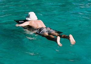 |
Colin goes rafting on the lakes, on a Thermarest |
I couldn’t wait to get started on the climb, but when you are camping at 4000m in a deep gorge, you find that it is not all that warm in the morning, and that the toasty inside of your sleeping bags exerts an almost irresitible force. It is just as well that for one of us at least, the desire to climb – or, admit it, race – is just that little bit stronger.
It was a brilliant cloudless morning. Once on the climb, we could very soon begin to see all the mountains properly, and every pedal stroke took us higher. From Huandoy all the way round to huge glaciers of Huascarán was a ring of snowy mountains: Pisco, Chacraraju, Yanapaccha. The zigzags carry you up close to Huascarán; from here it is two dome summits above a vast glacier and moraines. The vastness of the glacier, that mass of ice, is astonishing – we are simply not used to seeing anything at all quite that big. The most attractive peak was Chopicalqui, a symmetric and steep pyramid to the side of Huascarán; the biggest thrill was to reach 4500m by bike, for our first time.
Chopicalqui |
Another hour or so of bumpy descent took us to the ‘main’ road, which was a little smoother, and the 400m climbing up to San Luis at least mostly gradual. This was a beautiful and tranquil area, no traffic on the road, the farmsteads attractive traditional houses with red-tiled roofs. The lower sun of the late afternoon cast longer shadows, and the light was soft and golden. Along the roadside were a series of shrines in a Roman or Italian style – perhaps stations of the cross – and with the eucalyptus standing in for cypresses, it all looked very Tuscan. We got to San Luis after the last light had faded from the sky, about an hour after I’d felt myself to be completely spent.
The 20km to Chacas took us all of next morning, or what was left of the morning after we had treated ourselves to the late start that we thought we could afford. The road climbs in and out of the valley in an absolutely infuriating way, often pretty steeply. Chacas is delightful. It has a broad and elegant plaza, and all the wooden balconies are intricately carved – for this, credit is due to an Italian priest “Don Bosco”, who has set up a woodcarving workshop here.
As we climbed back towards the mountains, the settlements thinned out, and then the climb proper started in earnest with some steep and very rough zigzags. Now the mountains were reappearing, and the view straight ahead began to be dominated by the vast wall of rock and ice of Nevado Contrahierbas. Now we were also very tired. We knew from the map that there was a flattish piece of ground with a small lake, at about 4000m, and we had planned to camp there, but it was taking an interminable time to reach. We stopped at the first place possible – and it was absolutely perfect. It couldn’t help but have a splendid view of the glaciated flanks of Contrahierbas, but the big surprise was our first sight of the glorious and striking cone of Nevado Ulta. We had a stream nearby, and gnarly, licheny trees and shrubs, and the grass underfoot in soft and bouncy hummocks. We cooked dinner; company arrived. They were nice cows, but they had horns, and no fear, and too much curiosity. And we, correctly, doubted their ability to detect and avoid tent guy lines at night.
Dawn in the mountains was as beautiful as anything could be; Ulta glowed pink against the still-dark but clear blue sky. We climbed closer and closer to Ulta, and to Contrahierbas – the pass crosses the high rocky ridge that links the peaks. We discovered Ulta has a lake below it. The snowfields and glaciers on Contrahierbas were marvellous, a captivating sight; the snow astonishing clean, in billowing shapes, like whipped cream, and the ice so clear and blue.
 |
mmm ... ice cream |
The climb was hard; the road all boulders and sand. Possibly the worst road yet, though I suspect we thought that about every road we encountered. Like the Portachuleo de Llanganuco, the pass summit is a notch in the ridge, and this very unmistakeable feature was visible from a long way below. Some trick of perspective made it look a fearsome height above us. Perhaps this could be explained by it actually being a fearsome height above us.
The Punta Olimpica is at 4655m, about 240m lower than the Peru IGN survey claims; we found all the heights above 2500m were overestimates. Pretty high, in any case. I should say that we had no real trouble with the altitude, as we had taken the week at Caraz to acclimatise well. We’d had mild headaches while riding up to 4000m the first time, and Colin had invented a new variety of snoring which he delighted in practising throughout the night, and that was about all, apart from being terribly slow – but nobody needs to know about that.
And here were new views. A new side of Huascaran, Chopicallqui again, and the long ridge of Contrahierbas – like the other side, adorned with bewitching snowfields. The ridge we had to descend is vertiginously steep, and it is a wonder how they got the road here. The roadsides are necessarily precipitous, especially near the top; I would not like to do this journey in a bus. (And that provides an answer to the question – Why do we cycle in these places? Because we’re too scared to take the buses).
We decended to a magically serene high valley. It was a lovely place but we were too hungry and tired to appreciate it, and it was still a long way to Carhuaz. But pleasures are best when they are extreme. After 6 hours hard riding on a rumbling stomach, even the most basic lomo saltado would have been as delicious and exquisite as a Michelin-starred menu. In Carhuaz, we really hit the jackpot by zooming in on one of the best restaurants in the Callejon. And from there, we rode on and, caked in the grime and dust and sweat of two days, rolled up to the best hotel in Huaraz, where we ordered champagne.
We had had almost cloudless weather for those four days, but for the final week of the trip, there were clouds over the summits. We took a long morning ride up to Laguna Llaca, another lovely spot up a terrible road – and I swear this really was worst road yet – but didn't see much and although it was another 4000m contour to add to our collection, the ride really only resulted in us being even more tired. I had been riding myself into the ground, and the more tired you are the more susceptible you are to ailments, and I had succumbed to a mild stomach upset. We rode on to Olleros. And from Olleros, towards Chavin, for our token ruin for the holiday, via yet another 4000m pass. At this end of the Callejon you are at the high end of the valley, and although the land is higher, it is less rugged. The road follows a broad valley up, and there is a large and attractive lake on the way, and it was here that we saw our only llama of the trip, though we suspected it of being purely ornamental, and having something to do with the cafés nearby, mangy beast though it was. The road is paved, mostly, the climb well graded, and we had left the camping stuff in Huaraz. We should have romped up but I was stuffed, and the hail at the top of the pass had not exactly helped.
The ruins were quite good. There is a sort of flattened pyramid thing which is not very impressive from the outside; inside, however, is a labyrinth of dark passages and vaults. In one tunnel, down a crevice that’s barely wide enough for me, is the mysterious Lanzon, a monolith carved, with an art exotic to us, into the form of a serpent god. The outside of the temple had been built with carved stone heads, all but one of which are now in the museum. They were presumably meant to inspire fear, but to us they seemed more like characterful gargoyles.
The cycling had all but fizzled out. The weather didn’t improve and neither had we recovered much. We took a combi to the top of the pass and freewheeled most of the way back to Huaraz. I think we managed to write a postcard the next day and work the jacuzzi bath but that’s about all. The hardest part of the trip still remains – deciding where on earth we go next.